


Damaging Winds Over 110km/h; Blizzard Conditions in the North; Icy Conditions in the North and East
- Weather Watch
- Feb 23, 2019
- 9 min read
Updated: Feb 24, 2019

We are currently tracking a powerful Texas low that will track through Northern Ontario bringing the risk of 20-40cm of snow, 5-10, locally 15mm of ice, damaging winds over 110km/h, possibly 120km/h, and thunderstorms across most of the province.
Freezing Rain Accretion
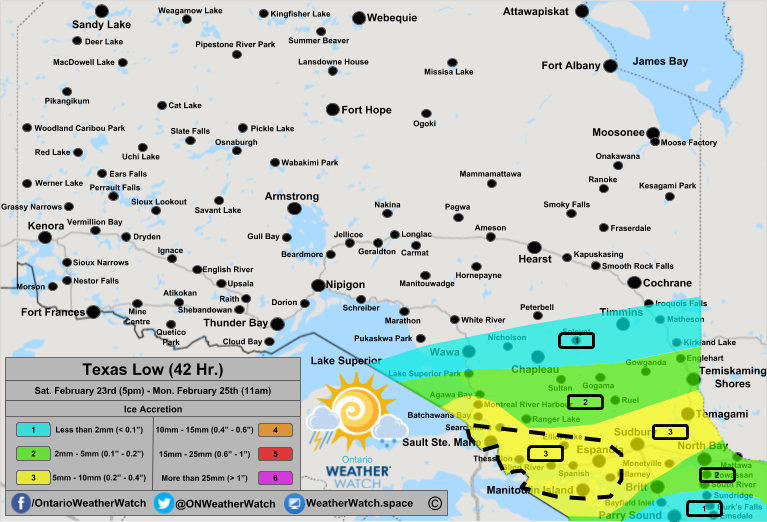
Timing:
8pm-12am, Saturday 23rd into Sunday 24th - Freezing rain begins to move across Manitoulin Island, the Northern Bruce Peninsula extending into the Sault Ste. Marie area. Freezing drizzle across portions of Southern Ontario for areas around Orangeville and areas north of Belleville.
12-4am, Sunday 24th - Moderate to heavy freezing rain for areas east of Lake Superior including Agawa Bay, Batchawana Bay, Sault Ste. Marie extending inland to include Sultan, Ranger Lake, Elliot Lake, and Manitoulin Island. Light freezing rain/freezing drizzle continues along the eastern side of the Bruce Peninsula extending across the Dundalk Highlands into the Kitchener/Waterloo area. The scattered freezing precipitation continues across much of Central and Eastern Ontario, just north of Lake Ontario.
4-8am, Sunday 24th - Freezing rain moves east in Northeastern Ontario with the heavy to moderate freezing rain ending for areas directly east of Lake Superior as those areas switch over to snow. The moderate to heavy freezing rain will spread east along the Quebec border to include Sudbury, North Bay, Gogama, Temiskaming Shores and Englehart. Freezing rain/drizzle continues for areas east of Georgian Bay such as Parry Sound and Huntsville, including most of Eastern Ontario. The freezing precipitation will change over to rain for portions of Manitoulin Island, the Bruce Peninsula and Southwestern Ontario.
8am-12pm Sunday 24th - Freezing rain will change over to snow or rain from west to east throughout this period. By 12pm, the freezing rain should be mainly over with besides some lingering pockets of freezing precipitation along the Ottawa River. This precipitation will end by the early afternoon (1-3pm).
Impacts:
Based on the forecasted winds and the forecasted amount of ice, we are expecting widespread tree damage across the 'Area of Interest' area with widespread power outages. Not only this, but we are also expecting widespread damage outside of this region for the remaining portions of Manitoulin Island extending towards Sudbury and Montreal River Harbour.
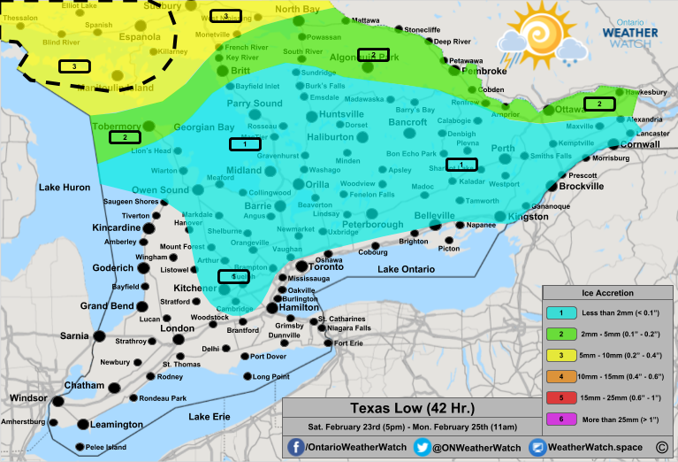
Blue or '1':
Areas in the blue or marked with a '1' can expect less than 2mm of ice. Across Southern Ontario, accretion totals near a trace to 2mm can be expected from the Bruce Peninsula (Lion's Head and south) extending southeast towards Grey County into the Dundalk Highlands, including areas away from Lake Ontario such as Guelph, Cambridge, and Kitchener. This risk also extends east into Central and Eastern Ontario to include, Barrie, Midland, Orillia, Parry Sound, Huntsville, Haliburton, Bancroft, Perth, Cornwall, Brockville, Kingston, Belleville, Peterborough, and Newmarket, including everything in between. Areas in Eastern Ontario towards Parry Sound-Huntsville-Bancroft-Perth-Cornwall and areas east are more likely to see totals closer to 2mm. Isolated pockets across the region between 2-5mm are possible. In Northern Ontario, areas between Wawa, Timmins and the Quebec Border, including Chapeau, Kirkland Lake and Matheson can expect between a trace and 2mm of ice. Depending on the track of this low, this range may shift slightly north to include White River and Cochrane or slightly south to include Gogama and Temiskaming Shores.
Green or '2':
Areas in the green or marked with a '2' can expect between 2 to 5mm of ice. Across Southern Ontario, accretion totals between 2 to 4mm can be expected over the northern portion of the Bruce Peninsula, including Tobermory, as well as, areas along the Ottawa River extending into Algonquin. This includes Hawkesbury, Ottawa, Arnprior, Pembroke, Deep River, Mattawa, Algonquin Park, Powassan, and Britt. Local accretion totals between 3 and 6mm are also possible, mainly towards the north and directly along the Quebec border. Local pockets between 1 and 3mm are possible. In Northern Ontario, 2-4mm of ice can be expected from an area between Lake Superior Park and Agawa Bay extending to the Quebec border, including Temiskaming Shores, Ranger Lake, Gogama and Englehart. Areas towards Agawa Bay and Ranger Lake could see locally higher amounts between 3 and 6mm. Areas towards the north and central regions such as Lake Superior Park, Gogama and Englehart could see locally fewer amounts between a trace and 3mm.
Yellow or '3':
Areas in the yellow or marked with a '3' can expect between 5 and 10mm of ice. Across Northern Ontario, accretion totals between 4 and 8mm include Batchawana Bay, Sault Ste. Marie, Manitoulin Island, Elliot Lake, Sudbury, Espanola, and Temagami. Local amounts could be as low as 2-4mm and as high as 10mm. Locally higher amounts in the 'Area of Interest' may reach as high as 15mm of ice. This includes Manitoulin Island, Espanola, Blind River, Elliot Lake, and Sault Ste. Marie.
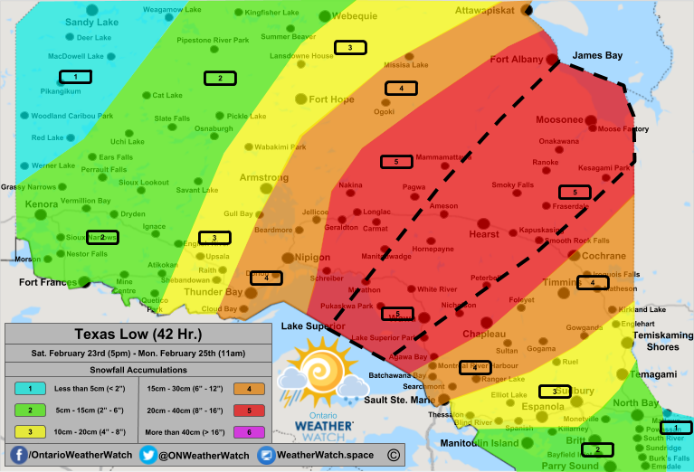
Snowfall and Ice Pellet Accumulation
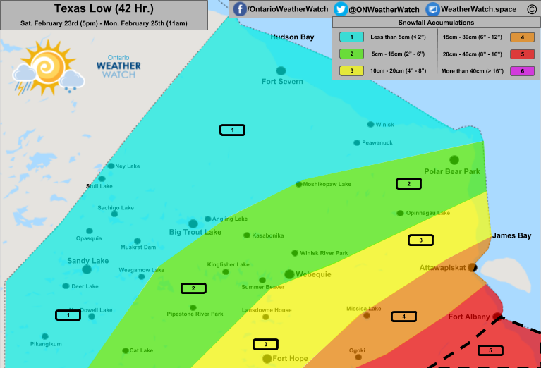
Timing:
12pm-12am, Saturday 23rd into Sunday 24th - Light to moderate snow will develop and continue across most of Northern Ontario extending from the Manitoba to Quebec Border between the United States Border and Hudson Bay. There will be clearing pockets although most of the region should have a light snowfall throughout the day.
12-4am, Sunday 24th - Light to moderate snow will continue across all of Northern and Far Northern Ontario. Moderate to heavy snow will begin to push across the region impacting areas between Thunder Bay and Lake Nipigon extending through Lake Superior to include areas just east of Lake Superior such as Wawa, White River, and Peterbell.
4-8am, Sunday 24th - Light to moderate snow will continue across much of Far Northern Ontario and areas along the Manitoba Border. Moderate snow will continue from Fort Frances extending to Lake Nipigon to Ogoki to Fort Albany. Areas south of this line will also encounter those moderate snowfall rates. Across Northeastern Ontario, moderate snow to heavy snow will continue for areas between and including Cochrane, Hearst, Marathon, Wawa, Agawa Bay and Chapleau. Freezing rain will change over to light snow with pockets of moderate and heavy snow. This includes Sault Ste. Marie, Ranger Lake, Batchawana Bay and possibly Gogama.
8am-12pm Sunday 24th - Light snow will continue along the Manitoba Border extending northeast towards places such as Cat Lake, Pipestone River Park, Kasabonika and Polar Bear Park in Far Northern Ontario. Light to moderate snow will continue across the southern portion of Northeastern Ontario such as Sudbury, Sault Ste. Marie, Searchmont, Agawa Bay, Sultan, Gowganda and Kirkland Lake. Moderate snow will continue across portions of Northern Ontario to include Thunder Bay, Armstrong, Wawa, Marathon, Timmins, Hearst, Nakina, Manitouwadge and Mammamattawa. Moderate to heavy snow will continue for Moosonee, Smoky Falls, Fraserdale and Kesagami Park.
12-4pm Sunday 24th - Light snow will spread east from the Manitoba Border and the snow will begin to end from west to east. The light snow will include Thunder Bay, Armstrong, and Ogoki. Moderate snow will continue for all of Northeastern Ontario including Moosonee, Timmins, Wawa, Marathon, Sault Ste. Marie, Sudbury, Manitoulin Island, North Bay, Chapleau, Hearst, and Carmat/Longlac. Snow will develop and spread across most of Southern Ontario following the rain/freezing rain. This includes all of Southwestern Ontario, the Extreme South, the Golden Horseshoe, the GTA, Central Ontario and most of Eastern Ontario, although areas east of a line between Kingston and Mattawa may still be experiencing some lingering showers.
4-8pm Sunday 24th - Light snow will continue eastward across Northern Ontario with the light snow reaching Marathon, Nakina, Fort Hope, and Attawapiskat. Light to moderate snow will continue for much of Northeastern Ontario including Wawa, Timmins, Hearst, Sault Ste. Marie and Chapleau. Moderate snow will continue along the Quebec Border such as North Bay, Temagami, and Moosonee. Moderate snow, with pockets of light snow, will continue across all of Southern Ontario. There will be some clear patches and some possibly heavy lake-effect patches.
8pm-12am Sunday 24th into Monday 25th - Light snow will continue to spread east including Timmins, Sault Ste. Marie, Hearst, and Chapleau. Light to moderate snow will continue for the Quebec Border extending into Moosonee. In Southern Ontario, moderate to at times heavy snow squalls will continue across the region. The heaviest snow will fall east of Georgian Bay and Lake Huron.
12am-12pm Monday 25th - Snow will end across Northern, Central and Eastern Ontario. Lingering lake-effect snow will continue to impact areas east and southeast of Lake Huron, possibly extending into the GTA. By the late evening, the snow should end with some linger flurries.
Impacts:
Across Northern Ontario in the 'Area of Interest,' we are watching the risk for blizzard conditions. As of now, the intensity of the snow, the length it falls, the amount of snow and the expected visibility will all reach blizzard criteria although winds gusting over 40km/h may not be reached across portions of Far Northeastern Ontario. Besides this risk, near-blizzard like conditions for much of Northern Ontario with whiteout conditions extending throughout all of Southern Ontario. Road closures are possible and likely.
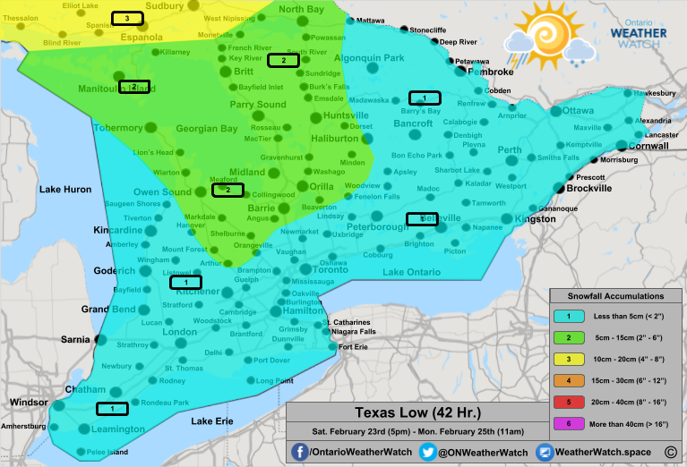
Blue or '1':
Areas in the blue or marked with a '1' can expect less than 5cm of snow. This includes much of Southern Ontario which could see between 2 and 4cm of snow. Areas towards the Extreme South and Niagara regions may see fewer amounts towards 1 to 3cm while areas east of Lake Huron through Bruce, Huron and Perth Counties, locally higher amounts towards 4 to 8cm are possible. In Northern Ontario, areas along the Manitoba Border including Red Lake, Pikangikum, Sandy Lake, Weagamow Lake, Big Trout Lake, Ney Lake, Fort Severn, and Winisk can expect between 1 and 3cm of snow, locally 4cm.
Green or '2':
Areas in the green or marked with a '2' can expect between 5 and 15cm of snow. In Southern Ontario, snowfall totals between 5 and 10cm are likely along the Bruce Peninsula extending southeast into the Dundalk Highlands, south of Collingwood through Shelburne. Into Central Ontario, extending from Barrie, Midland, and Orillia inland towards Fenelon Falls, Haliburton, and the western side of Algonquin Park, and everything in between towards Georgian Bay. Locally higher amounts between 15 and 25cm are possible between Meaford, Collingwood, and Markdale as well as Britt, Parry Sound, Huntsville, and Burk's Falls. In Northern Ontario, snowfall totals between 10 and 15cm are likely over portions of North Bay, Monetville, Manitoulin Island extending into Mattawa. In Northeastern Ontario, 5 to 10cm is likely over Kenora extending towards Ears Falls, Cat Lake, Sioux Lookout, Sioux Narrows, Fort Frances, and Pipestone River Park. This also includes Kingfisher Lake, Moshikopaw Lake, Polar Bear Park, and Opinnagau Lake. Areas towards the east can expect between 8 and 12cm of snow, locally 15cm. This includes Atikokan, Ignace, Savant Lake, Pickle Lake, Summer Beaver, Webequie, and Winisk River Park.
Yellow or '3':
Areas in the yellow or marked with a '3' can expect between 10 and 20cm of snow. This includes Thessalon, Blind River, Espanola, Sudbury, Temiskaming Shores, Englehart, Temagami, Elliot Lake, and Ruel. These totals also include ice pellet totals which may occur for a period of time before and/or after the freezing rain. Towards the west, snowfall totals between 12 and 18cm are possible between and including Raith, Upsala, Armstrong, Fort Hope, and Lansdowne House. Locally fewer amounts are possible depending on the exact track of the system for portions of Far Northern Ontario, between Lansdowne House and James Bay.
Orange or '4':
Areas in the orange or marked with a '4' can expect between 15 and 30cm of snow. This includes Thunder Bay, Nipigon, Beardmore, Jellicoe, Ogoki, Missisa Lake, and Attawapiskat. The exact track may lower the amount for places such as Missisa Lake and Attawapiskat. Towards the south, areas including and between Sault Ste Marie, Montreal River Harbour, Timmins, Gogama, Cochrane, Matheson, and Kirkland Lake may see snowfall totals between 15 and 25cm of snow with locally higher amounts towards 30cm for areas nears Foleyet and Cochrane. The exact track may shift this region slightly further north or south.
Red or '5':
Areas in the red or marked with a '5' can expect between 20 and 40cm of snow. This includes Schreiber, Geraldton, Mammamattawa, Fort Albany, Moosonee, Kesagami Park, Smoky Falls, Hearst, Smooth Rock Falls, Chapleau, Agawa Bay, and Wawa. Areas between Marathon and Wawa extending northeast towards Smooth Rocks and Mammamattawa extending into Moosonee and everything in between could see locally higher amounts towards 50cm.
Damaging Peak Winds GUSTS

Impacts:
Based on the forecasted wind gusts, we are expecting widespread power outages, building damage and coastal flooding. Power outages could last days for some people as there is a risk for mass-outages. Across the shores of the Great Lakes, coastal flooding from abnormally high waves alongside ice shoves (ice tsunami) will cause coastal road closures and structural damage. Road closures are possible.
Green or '2':
Areas in the green or marked with a '2' can expect peak wind gusts between 70 and 80km/h. This includes areas along the Ottawa River and much of Northeastern Ontario. This includes Ottawa, Pembroke, Eastern Algonquin Park, Ranger Lake, Agawa Bay, Chapleau, and Wawa.
Yellow or '3':
Areas in the yellow or marked with a '3' can expect peak wind gusts between 80 and 90km/h, with isolated gusts towards 95km/h. This includes Cornwall, Brockville, Perth, Bancroft, Haliburton, Western Algonquin Park, Sudbury, Espanola, Elliot Lake, and Montreal River Harbour.
Orange or '4':
Areas in the orange or marked with a '4' can expect peak wind gusts between 90 and 100km/h, with isolated gusts towards 110km/h. This includes much of Southern Ontario including Essec, Lambton, Middlsex, Huron, Perth, Grey, Wellington, Waterloo, Halton, Peel, Simcoe, Dufferin, Oxford, Kawartha Lakes, Peterborough and Northumberland counties and regions, including Kingston, Britt, Huntsville, Blind River and Sault Ste. Marie.
Red or '5':
Areas in the red or marked with a '5' can expect peak winds between 100 and 110m/h, with isolated gusts towards 115 or even 120km/h. This includes Prince Edward County, Hamilton, Brantford, Delhi, Manitoulin Island, the Bruce Peninsula, Parry Sound, Bayfield Inlet and areas northwest of Midland.
Purple or '6':
Areas in the purple or marked with a '6' can expect peak winds between 110 and 120km/h, with isolated gusts towards 125 or even 130km/h, mainly along the southern shores of the Niagara region, between Port Maitland and Fort Erie. This area includes the Niagara Region, Long Point, Dunnville, Port Dover and Pelee Island.
Thunderstorms
This system will spread across Southern Ontario on Sunday morning bringing a swath of 5-10mm of rain, locally 10-20mm. With this rain and increase in temperature, we are closely watching the risk for some non-severe thunderstorms portions of Southwestern Ontario including the GTA and Extreme South. Locally heavy rain and a bolt of lightning can't be ruled out.
Beginning late in the day on Monday, this system and its effects will have pulled away into Atlantic Canada. We are closely watching another system between Tuesday and Thursday which could bring a swath of 10-20cm of snow across portions of Southern Ontario. More information on that system closer to the timeframe.
- Lead Forecaster Justin M
Comments